Friday 26 February 2016

Age SHALL Weary Them ...

So, are we getting old, or just soft?

Yesterday, Dianne and I rode somewhere different. Well, not entirely different, but somewhere we hadn't ridden for at least fifteen years and perhaps even twenty - or maybe more. (My aged memory doesn't remember exactly.)

The story of this ride involves a hill, bike gears and stuff like that, but before I go into the detail here is a photo of Di arriving at the little flat spot on that hill, at Glenlusk, just before we turn off into Molesworth Road and the final short bit of climbing before a nice long descent ...

Di riding in dappled sunlight
I was pleased (to tell the truth I was quite relieved) to see a big grin on her face as she had just come up over one of the steeper pinches of the climb, which happens to be right before the end. Here's a cross-section of that hill ... 

Glenlusk Hill
(Right click on the photo to see the full size image and gradient details).

While I'm at it, here's an image showing the whole ride ...

New Norfolk via Glenlusk and Molesworth

... and a cross-section highlighting the hill ...


We had different bikes the last time we rode up the Glenlusk hill. The gearing wasn't nearly as low. We both had standard cranksets with 53/39 tooth chain rings.  I think Di's biggest cog on the back was a 27 tooth while mine was a 25 tooth. We are now riding compact cranksets and have much bigger cogs on the back. (For non-cyclists reading this, that's quite a difference.) All I can say is that I'm glad we weren't riding our old bikes: we mightn't have got up the hill this time around! And I'm sure that we used to find the going up this hill a whole lot easier.

So, back to the question at the start of this post. Is it age, or just softness that has made the difference all these years later? Well, let's look at the evidence. Here's a photo of Di at Banjo's in New Norfolk where we stopped for morning tea ...


Hair colour is certainly different from what it was way back then and there might be a few lines that weren't there then (I might get hit for that). But look at that enthusiastic, youthful smile.

And here's one of me ...


Yep, there are a few lines here too and the colour of my hair has changed as well. But hey, how could you call a bloke with a hairstyle like that old?

Hmmm. It would be fair to say we are older, but don't call us old! So, it must be that we've just gotten soft over the years. Of course a few knocks along the way have contributed. Di's hip arthroscopy a decade ago and subsequent advice to stop running along with my hip replacement in 2009 followed by the same advice means that it's not as easy to get a good hard workout to load up the legs. Our muscles might not be quite as resilient as they once were.

We might not ever be as strong as we once were ... actually we definitely won't ever be as strong as we once were. But maybe we can get some of that strength back. While we have been riding hills, including the climb up Mount Wellington, which gets a "hors categorie" rating and the Climbing Cyclist website rates as the fourth hardest climb in Australia, we haven't been doing hills with so much sustained steepness as yesterdays hill. 

I think we've got in the habit of settling into a rhythm on climbs so that we don't burn ourselves out, and we know we will often have to finish our rides punching into a sea breeze for 10 or more kilometres. And maybe riding so much on the eastern shore where there aren't so many hills has softened us up too.

Anyway, both of us were really glad to have had a bit of a wake-up call. We discovered when we got home that the itinerary for our upcoming tour had come through. It looks both absolutely wonderful and quite daunting, with some very long days in the saddle, so we know we need to get cracking with our training. More hills. Steeper hills. And we did actually enjoy the struggle up the Glenlusk hill. We'll put it back into our collection of regular rides after a long absence from that list.

Unexpected Bonus!

One reason for going up through Glenlusk yesterday was to get a bit of respite from the wind. We thought that once we got to Berriedale and turned west we might be sheltered by the hill. It turned out that we were right, so we only had about twelve kilometres into the headwind to start the ride. The descent to Sorrel Creek was quite sheltered too and then we only had another five kilometres or so before we had a rest from the wind. But the real bonus of the ride was that we got back to Hobart and home before the sea breeze came through, with a nice little tailwind helping us along.

Here's a photo of us pleased as pie, back in the bike garage under the house at the end of our ride ...

Us? Old? No way man!

Sunday 14 February 2016

Rambling In and About Mt Field National Park

Spruiking Mt Field National Park

We like to have at least one walk - and preferably two or three -  at Mt Field National Park every year. This place has long been recognised for its natural beauty. Way back in 1885 the area around Russell Falls  - described by Parks Tasmania as "one of Tasmania's most treasured places" - was declared Tasmania's first nature reserve and then, along with Freycinet, Mt Field became one of Tasmania's first two National Parks in 1916. 

I have no idea how many times we've been to Mt Field. Di first visited the park in the winter of 1967 and she remembers it as a "terrible trip". The group she was with waded through deep snow on Tarn Shelf amid masses of blackened Pencil Pine skeletons (which were probably burnt in the massive fires that swept through the Central Plateau in 1960). Since that inauspicious occasion we've been to the park on many, many occasions in all seasons: with family, friends, school groups and lots and lots of visits as just a twosome. 

The park has such diversity, from tall trees to stunted alpine heath, waterfall to peatbog to broken rockscapes - lots and lots of broken rockscapes.  It's an old and shattered landscape with its own unique beauty. One of our most memorable visits was another winter trip when we wandered across to K Col in snow. Most of the way the snow was compacted and easy walking, but once we neared the col we found ourselves wading up to our thighs for what seemed an eternity. Finally we arrived at the col and were pitching our tent when a bunch of skiers effortlessly glided up to our campsite for a chat, having spent the day zipping around the outer reaches of the park. Overnight the weather turned warm and we laboriously waded all the way back to Lake Dobson. Not long afterwards we bought our first cross-country skis. 

Walking the Tarn Shelf - Lake Webster Circuit

Realising that we haven't been to Mt Field since I smashed my ankle, we decided to head up there yesterday for a hike.  There is a huge range of walks that one can do at Mt Field, from a half hour visit to one of the waterfalls to a fast-moving full day return trip out to Mt Field West, to more sedate overnight wanderings about the alpine. We decided to do the popular Tarn Shelf - Lake Webster Circuit but, for a change, in the reverse direction.

Along the first section towards Lake Webster we were treated to several visits from curious - or perhaps slightly resentful - black cockatoos. From the numerous mangled blooms scattered along the track it was clear they'd been feeding on the many banksia marginata in full flower alongside the track. They were very vocal and it was a real joy to be entertained for a half hour or so by our most favourite of birds. (We fervently hope that at least in the alpine areas of Tasmania, the quirky, endearing black cockatoos won't be pushed out by invasions of their noisy sulphur-crested cousins, which is happening a lot in southern Tasmania, another apparent consequence of climate change.) Because of the dense bush along this section of track we didn't get the opportunity for a good photo but were particularly delighted with a flappy flyover from a flock of six birds.

One of the highlights of the walk is reaching Twilight Tarn and spotting the historic hut ...

Twilight Tarn
It's an idyllic little spot and, dating back to the 1920's, was once a winter social hub, with skating parties on the lake and formal dinners in the hut, both accompanied by strains of classical music playing on a state-of-the-art phonograph.

It is upon reaching the tarns that the Pencil Pines start to appear. And what's so special about these trees? That causes me to mention them so frequently? Well, they are endemic to Tasmania, grow between only between about 750 and 1300 hundred metres above sea level, can live to over 1200 years and are part of the unique ambience of Tasmania's alpine lake and tarn environment. 

We really like actually walking when we're walking, and often have to consciously stop to take pictures. Once we reached Tarn Shelf we slowed ourselves down a bit and decided to do just that. The once blackened skeletons that Di remembers seeing back in 1967 are now ghostly ...

Pencil Pine skeletons

On what I would call the far end of Tarn Shelf (which perhaps should be called "Tarn Shelves",  as it isn't all one level but steps up in a series of small sections) most of these ancient and beautiful alpine trees were obliterated. In sheltered pockets small copses remain, but mostly one sees only alpine heath and masses of dead pines, with a scattering of Snow Gums.  

A little further along, the devastation isn't quite so bleak and there is a mixture of dead and living trees, albeit all younger ...

Young Pencil Pines amid old skeletons

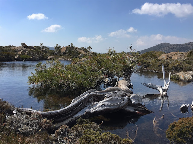
At one of the tarns along the shelf a couple of ancient survivors cling to life, now prostrate and bowed over the water. Here's one of them ...

Survivor
The park itself is an ancient and broken landscape, most notable at these higher elevations where vegetation can't easily get established and hide from the elements. In exposed areas where vegetation was able to get a foothold is where the big fire seems to have done its worst damage, yet tranquil pools can be found with a fragile but rich fringe vegetation ...

Contrasts
In under the shelter of the Rodway Range much of the vegetation escaped relatively unscathed and there is a rich mixture of heath, Pencil Pines and Fagus, which isTasmania's only deciduous tree ...

Mixed Tasmanian alpine vegetation
I'm going to sneak in a photo here from a previous perambulation along Tarn Shelf in the autumn, just so you can see what the Fagus looks like when it is on the turn ...

Autumn on Tarn Shelf
On the way back down to Lake Dobson one can opt for the Snow Gum Trail, which we always take so we can appreciate these hardy trees, twisted, bent but unbowed in the face of the ferocious winds that roar through the landscape. the first tree is a bit of an outlier, and coming upon it is like greeting an old friend ...

Hello, old mate
The greater mass is just down off the plateau, taking what shelter they can amidst the boulders ...

The hardy Snow Gums
Here's an aerial view of this particular walk ...


... and a map of Tasmania showing Mt Field's location on the edge of the Southwest Wilderness ...


... and, if you're reading this over the big water somewhere and aren't quite sure exactly where our little island lies in the greater scheme of things, this might help ...

Under Downunder
So, if you ever ramble around Tasmania down the track, please allow yourself enough time to have a proper look at our diverse environments. Drop into Mt Field if you can. I'm confident that you'll find it is well worth a visit.

Saturday 6 February 2016

Mount King William 1

The other day we bumped into our friend Libby Jackson at Fuller's Bookshop. While we were having a coffee together she told us about her recent walk up Mt King William. It sounded like a pleasant outing, we hadn't been there before and felt due for a walk somewhere different so we decided to check it out.

Here's what the King William Range looks like partway along the the approach track ...


Classic southwest Tasmania. Buttongrass plains with peaks rising above. You've got to love it - at least on a day like this.

The first part of the walk consists of pleasant strolling following an old,  gently rising four-wheel drive road, initially through old logged country and then through buttongrass and the unlogged lower slopes of the peak. At the end of the road the track up to the top of peak steepens immediately, and gets steeper the higher you go.

Here's a glimpse of some cliffs that appear about halfway up ...


Nearer to the top you traverse upwards to the right of the summit block ...


As an excuse to catch my breath I paused to take a photo of some Mountain Rocket a little past its best ...


and some Common Gentian ...


Views towards the west start to open up at this point. Here is the Lyell Highway disappearing into the forest and mountains and those of you who are more sharp-eyed might just be able to see Frenchman's Cap appearing towards the right of the picture just behind the hill in the foreground ...


As we approached the summit we were surprised to discover a collection of solar panels, antennae and small buildings ...


I thought this very odd fibreglass dome might have been used in the past for spotting fires ...


... but really wasn't sure.

We had a great lunch at the top and enjoyed the alluring views across the King William Range ...


... but I think my days of carrying a fully loaded pack through this sort of off-track terrain have come and gone!

There was a reasonable view of Frenchman's Cap, despite the light not being great over that way ...


On the way back down I paused to take a photo looking across Lake George towards Lake King William which, along with the rest of the Hydro Tasmania storage dams, is very low at the moment ...


Here's a panorama of Lake King William taken a little lower down the descent ...


Although it covers a large area, it doesn't look to me like this lake holds a huge volume. I wonder what the depth is in the deepest part at the moment?

Here's a view of the King William Range that I took when we did the nearby Rufus - Hugel Circuit back in 2006 ...


Finally, for folks not familiar with the geography of Tasmania, here is an image that will orient you as to the locations of Mt King William ...


We thought is was quite a pleasant walk but would recommend doing it as a part of a multi-day stay in the area.